Saturday, December 13, 2008
Now What? GeoBlog Viewing Options
We've moved this post to the BlurbBits blog.. Click here to visit.
Wednesday, November 19, 2008
A BlurbBit Sample Album With Route
This is the same album but instead of using our general album location, I added our first years sailing track and Bora Bora (who doesn't know about it?)
 Don't forget to check out all the geotagged photo maps after you've loaded the photos: click on the Geo-Photos button to get a summary map and then click on the Location Map to see each photos location on a map.
A BlurbBit Sample Album
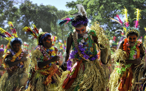
Our first year was an amazing eye opening experience about what this cruising lifestyle has to offer. Nothing can ever replace your first remote island anchorage after a 24 day non-stop no-land passage. Nothing!!
 We saw some amazing things and met some wonderful natives and cruisers. How do you beat an adventure like this? and how do you go back to work?? (if you are my future boss.. just kidding;)
Tuesday, November 18, 2008
A Blog Photo Album of snaps360
More than just maps.. A blog album is a good way to highlight blogs with photos. We extract the first photo and use it in an album.
We've taken over 25,000 photos during our five year trip, we highlight one a week at snaps360.blogspot.com
enjoy the photos
We've taken over 25,000 photos during our five year trip, we highlight one a week at snaps360.blogspot.com
enjoy the photos
Thursday, November 13, 2008
Round the World Pacific Center
This is the default center with no special case handling other than the require split at 0 degree longtitude.
Round the World Atlantic Center
So here we have to cheat a bit.. By default the center of a circumnavigation is at 180 (360/2 = 180) however we might have some folks who, even though they loved the South Pacific, want the map centered in the Atlantic (it will automatically if < 180 degrees are covere). Here we add a special case %26center=0,0 and split the RTW path at 180 degrees. The results are
A BlurbBit
In order to make this work, the path needs to be split at 0 longitude. Have one path end at say 36.5,-0.1 and the other one start at 36.5,0.1. The - is important if the line crosses 0 degrees the underlying Google Static Maps will Wrap it the wrong way round the world (see previous post)
A BlurbBit Round the World - Bad
A round the World test - Bad
This is what it looks like when the path is Not split at 0 longitude. In this case all I did is change the - sign.. all that difference for a 0.1 of a degree!!
To Fix: Have one path end at say 36.5,-0.1 and the other one start at 36.5,0.1. The - is important if the line crosses 0 degrees the underlying Google Static Maps will Wrap it the wrong way round the world (like this example)
See next Post for Good Example
Monday, November 10, 2008
A BlurbBit About "From The Galley"
We were in Finike, with its fantastic markets when KT Started From The Galley. A gourmet experience that is making me fat.. but happy.
 This BlurbBit is a Photo Blog Album that is automatically generated from her Blog. It grabs the first photo (and blog location) and creates an album. You can preview each entry by clicking the
Notes button or go directly to the Blog entry by clicking Open Link
Sunday, November 9, 2008
New Zealand a Tour
New Zealand is an amazing place: Awesome scenery, fantastic people just an all around great time. We spent four months driving around both islands, 16,000 kM.. This is a collection of our best shots.

For more photos, details etc. Check out SailBillabong New Zealand
For more photos, details etc. Check out SailBillabong New Zealand
Saturday, November 1, 2008
A Full Trip BlurbBit
Our Sailing Photo Albums from the Past 5 Years and 30,000 miles in one BlurbBit
This BlurbBit shows our complete route (zoomed out) so far, our current location (zoomed in) and all of our Picasa Geotagged Photo Albums. Don't forget to check out the Photos IN the albums
This BlurbBit shows our complete route (zoomed out) so far, our current location (zoomed in) and all of our Picasa Geotagged Photo Albums. Don't forget to check out the Photos IN the albums
Thursday, October 16, 2008
Defining your location
Below are some examples of how you can define a blog post location with a BlurbBit Map.. and see the various results (via RSS feed etc). Embedded sizes are default examples and can be easily adjusted using the &height and &width Url parameters. The first location and image are used while extracting data for other views.
The following BlurbBit design mode options are available:
Only maps are shown however photos can be added.
BlogThis or Embed in Website/Blog Entry (with feed)
Embed in Website/Blog Sidebar (no feed)
The following Links and lat/lng text can be turned into popups with Dynamic GeoBlog Maps
Add link in Website/Blog (+ Graphic)
 BlurbBits for this Entry w/Location
must be placed after first photo or this graphic will be the main blog image
Add text link in Website/Blog
BlurbBits for this Entry w/Location
Note: To define a blog post location through a BlurbBit (like above), a &llz= parameter MUST be used!!
Blogger mobile via email:
You can also use a Lat/Lng text string like 36 17.6N,30 8.98E but it should only be used for Blogger Mobile support (because zoom levels cannot be defined). Use the llz= parameter llz=36.23,30.16,12 to define decimal degrees (no N,S,E or W.. use - values for S and W) and zoom levels.
To see a working example with BlurbBits, Lat/Lng text AND Dynamic GeoBlog maps visit our sailing blog.
Blogger-in-Draft
You can also use the new Blogger in draft editor to geotag a post, however zoom level is not currently stored and re-editing of the post within standard blogger deletes the location. The good news is this means Blogger will have direct geotagging support in the future so geotagged posts are NOT going away. We also have a documented migration path if you want to use the lat/lng defined by BlurbBits within Blogger-in-Draft.
The following BlurbBit design mode options are available:
Only maps are shown however photos can be added.
BlogThis or Embed in Website/Blog Entry (with feed)
Embed in Website/Blog Sidebar (no feed)
The following Links and lat/lng text can be turned into popups with Dynamic GeoBlog Maps
Add link in Website/Blog (+ Graphic)
must be placed after first photo or this graphic will be the main blog image
Add text link in Website/Blog
BlurbBits for this Entry w/Location
Note: To define a blog post location through a BlurbBit (like above), a &llz= parameter MUST be used!!
Blogger mobile via email:
You can also use a Lat/Lng text string like 36 17.6N,30 8.98E but it should only be used for Blogger Mobile support (because zoom levels cannot be defined). Use the llz= parameter llz=36.23,30.16,12 to define decimal degrees (no N,S,E or W.. use - values for S and W) and zoom levels.
To see a working example with BlurbBits, Lat/Lng text AND Dynamic GeoBlog maps visit our sailing blog.
Blogger-in-Draft
You can also use the new Blogger in draft editor to geotag a post, however zoom level is not currently stored and re-editing of the post within standard blogger deletes the location. The good news is this means Blogger will have direct geotagging support in the future so geotagged posts are NOT going away. We also have a documented migration path if you want to use the lat/lng defined by BlurbBits within Blogger-in-Draft.
Subscribe to:
Posts (Atom)

